Introduction
I've travaled a lot and kept track of the places I've been. I wanted to store this data and be able to display it but all online tools I've used for this purpose have either held my data hostage or gone out of business.
I set out to create a simple site that keeps my travels in YAML files without any databases or hard to manage dependencies. You can manage it completely using just Git, a text editor and a free account at Heroku.
Your data is in a simple to parse YAML format and the site provides end points to convert it to JSON or industry standard KML.
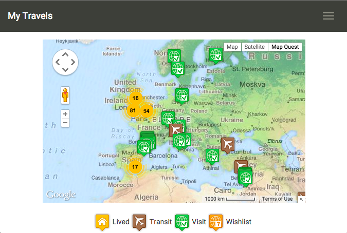
My own travels built using this software can be seen here.
Follow the links to the left to learn how to install, configure and add points.
Features
- Responsive design that works on mobile and PC
- A menu of pre-defined views so you can draw attention to a certain area of the map
- Support multiple datasets to let you track places you've been and places you'd like to go
- Points can be catagorized by type of visit like places you've lived, visited or transited through. Each with their own icon.
- Points can have urls, text, images and dates associated with them
- Point clustering that combines many points into one when zoomed out with extensive configuration options
- Several sets of colored icons for point types and clusters. Ability to add your own.
- Support creating links to Flickr galleries, wider support to follow with a plugin interface (1.5.0)
- A web based tool to help you visually construct the YAML snippets needed using search with the option to save them server side
- Geocoding page usable on a mobile device and supports using current location
- Optional authentication around the geocoder
- Support bootswatch themes
- Support for 3rd party map tile sets like Map Quest and Open Streetmap
- Full control over the Google Map like enabling or disabling the street view options
- Export to KML for viewing in tools like Google Earth
- Google Analytics support